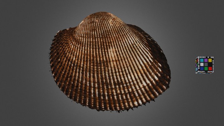
Arcidae

Ark clam is the common name for a family of small to large-sized saltwater clams or marine bivalve molluscs in the family Arcidae. Generally less than 80 mm long, ark clams vary both in shape and size. They number about 200 species worldwide.

Arcidae

Lozouet Pierre · CC BY 4.0 · via Wikipedia/Commons. May be a photograph of a specimen, or an artist’s reconstruction — an interpretation of a skeleton, since colour and soft tissue are almost never preserved.

On record

Recorded, not inferred
Sits inside
ArcoideaPBDB
Diet
suspension feederPBDB
Life habit
epifaunalPBDB
Motility
facultatively mobile, attachedPBDB
Vision
limitedPBDB
Environment
lagoonal,coastal,inner shelf,outer shelf,oceanic,brackish,freshwaterPBDB

Time the record covers

At least 283 million years on record.

The record covers at least 283.3 Mya to 11.7 ka. No occurrence read is dated outside 290.1 Mya to 0 Mya.

Permian — about 5 of 5571 occurrencesPermianEarly Triassic — about 0 of 5571 occurrencesMiddle Triassic — about 12 of 5571 occurrencesLate Triassic — about 15 of 5571 occurrencesLate TriassicEarly Jurassic — about 10 of 5571 occurrencesEarly JurassicMiddle Jurassic — about 69 of 5571 occurrencesLate Jurassic — about 65 of 5571 occurrencesEarly Cretaceous — about 153 of 5571 occurrencesEarly CretaceousLate Cretaceous — about 694 of 5571 occurrencesLate CretaceousPaleocene — about 109 of 5571 occurrencesEocene — about 570 of 5571 occurrencesOligocene — about 248 of 5571 occurrencesMiocene — about 1870 of 5571 occurrencesPliocene — about 818 of 5571 occurrencesPleistocene — about 868 of 5571 occurrences296–286 Mya — about 0.6 occurrences286–276 Mya — about 0.4 occurrences276–266 Mya — about 0.7 occurrences266–256 Mya — about 3 occurrences256–247 Mya — about 0.6 occurrences247–237 Mya — about 12 occurrences237–227 Mya — about 4 occurrences227–217 Mya — about 0.9 occurrences217–207 Mya — about 0.9 occurrences207–197 Mya — about 12 occurrences197–187 Mya — about 2 occurrences187–178 Mya — about 4 occurrences178–168 Mya — about 12 occurrences168–158 Mya — about 70 occurrences158–148 Mya — about 39 occurrences148–138 Mya — about 14 occurrences138–128 Mya — about 35 occurrences128–118 Mya — about 42 occurrences118–108 Mya — about 38 occurrences108–99 Mya — about 64 occurrences99–89 Mya — about 81 occurrences89–79 Mya — about 62 occurrences79–69 Mya — about 300 occurrences69–59 Mya — about 309 occurrences59–49 Mya — about 107 occurrences49–39 Mya — about 281 occurrences39–30 Mya — about 321 occurrences30–20 Mya — about 375 occurrences20–9.9 Mya — about 1129 occurrences9.9–0 Mya — about 2248 occurrences283.3 Mya11.7 ka296 Mya0 Mya

5,571 occurrences of Arcidae on record, most of them in the Miocene. The Paleobiology Database records this as a living group. Bar height is expected occurrences, not a count: each fossil is spread across the span it is dated to, so a tall narrow bar means tight dating and a low wide one means loose.

When

5,571 occurrences

These are dates about fossils, not the animal: the record can only begin after it arose and end before it died out, so either end may reach further. Shares are expected occurrences: a fossil dated to a span is counted partly in each period it straddles. More on what this infers.

Found in

652 formations

Gatun — 9.35°N, 79.81°WGatun — 9.35°N, 79.82°WGatun — 9.35°N, 79.85°WGatun — 9.28°N, 79.97°WGatun — 9.29°N, 79.92°WGatun — 9.17°N, 80.00°WGatun — 9.12°N, 80.33°WCastilletes — 11.85°N, 71.33°WCastilletes — 11.93°N, 71.34°WCastilletes — 11.98°N, 71.29°WCastilletes — 11.92°N, 71.36°WProvidence — 31.87°N, 86.08°WProvidence — 31.97°N, 86.00°WProvidence — 31.86°N, 85.95°WProvidence — 31.92°N, 85.82°WProvidence — 31.89°N, 85.70°WProvidence — 31.95°N, 85.68°WProvidence — 31.92°N, 85.35°WProvidence — 31.84°N, 85.22°WProvidence — 31.76°N, 85.13°WProvidence — 31.73°N, 85.12°WProvidence — 31.80°N, 85.00°WProvidence — 31.96°N, 85.45°WProvidence — 31.89°N, 85.21°WCook Mountain — 31.29°N, 86.56°WCook Mountain — 31.31°N, 86.48°WCook Mountain — 31.75°N, 92.97°WCook Mountain — 32.35°N, 92.72°WCook Mountain — 32.32°N, 89.03°WCook Mountain — 32.04°N, 88.73°WCook Mountain — 32.10°N, 88.86°WCook Mountain — 32.32°N, 89.15°WCook Mountain — 32.36°N, 92.98°WCook Mountain — 32.52°N, 93.73°WCook Mountain — 30.50°N, 96.63°WCook Mountain — 30.30°N, 96.96°WCook Mountain — 31.47°N, 93.57°WCook Mountain — 31.43°N, 93.85°WCook Mountain — 32.17°N, 88.83°WCook Mountain — 32.14°N, 89.00°WCook Mountain — 32.10°N, 92.66°WCook Mountain — 31.32°N, 95.46°WCook Mountain — 30.90°N, 96.39°WCook Mountain — 32.87°N, 93.99°WCook Mountain — 31.93°N, 92.64°WCook Mountain — 31.09°N, 95.95°WCook Mountain — 30.01°N, 97.16°WCook Mountain — 31.25°N, 95.72°WCook Mountain — 31.20°N, 95.73°WCook Mountain — 29.95°N, 97.14°WCook Mountain — 30.63°N, 96.55°WCook Mountain — 31.11°N, 96.28°WCook Mountain — 30.64°N, 96.52°WCook Mountain — 30.07°N, 97.08°WCaloosahatchee — 25.95°N, 81.36°WCaloosahatchee — 25.75°N, 81.94°WCaloosahatchee — 26.89°N, 82.01°WCaloosahatchee — 26.77°N, 81.15°WCaloosahatchee — 26.70°N, 80.99°WCaloosahatchee — 26.34°N, 80.86°WCaloosahatchee — 26.76°N, 81.44°WCaloosahatchee — 27.77°N, 82.68°WCaloosahatchee — 26.75°N, 81.51°WCaloosahatchee — 26.76°N, 81.46°WCaloosahatchee — 26.96°N, 81.17°WCaloosahatchee — 26.75°N, 80.93°WCaloosahatchee — 26.96°N, 81.99°WCaloosahatchee — 26.79°N, 81.30°WCaloosahatchee — 26.13°N, 80.62°WByram — 32.01°N, 89.38°WByram — 32.18°N, 90.25°WByram — 32.48°N, 90.80°WByram — 32.32°N, 90.86°WByram — 32.41°N, 90.84°WEscondido — 29.59°N, 98.07°WEscondido — 29.30°N, 98.84°WEscondido — 29.34°N, 98.89°WEscondido — 29.29°N, 98.97°WEscondido — 29.39°N, 99.02°WEscondido — 29.36°N, 99.06°WEscondido — 29.27°N, 99.05°WEscondido — 29.34°N, 99.16°WEscondido — 29.24°N, 99.23°WEscondido — 29.32°N, 99.27°WEscondido — 29.25°N, 99.28°WEscondido — 29.18°N, 99.66°WEscondido — 29.10°N, 99.88°WEscondido — 29.09°N, 98.87°WEscondido — 29.08°N, 99.96°WEscondido — 29.06°N, 100.08°WEscondido — 29.05°N, 100.14°WEscondido — 29.03°N, 100.25°WEscondido — 28.87°N, 100.16°WEscondido — 28.96°N, 100.22°WEscondido — 28.92°N, 100.26°WEscondido — 28.76°N, 100.26°WEscondido — 28.72°N, 100.47°WEscondido — 28.66°N, 100.44°WEscondido — 28.53°N, 100.32°WEscondido — 28.26°N, 100.27°WShoal River — 30.72°N, 86.12°WShoal River — 30.72°N, 86.04°WShoal River — 30.65°N, 86.04°WShoal River — 30.63°N, 86.17°WShoal River — 30.69°N, 86.65°WChipola — 30.44°N, 85.19°WChipola — 30.57°N, 85.84°WChipola — 30.43°N, 84.98°WChipola — 30.59°N, 84.58°WChipola — 30.06°N, 84.49°WChipola — 30.47°N, 84.99°WWoodbine — 31.95°N, 97.32°WWoodbine — 32.73°N, 97.22°WWoodbine — 32.84°N, 97.08°WWoodbine — 32.77°N, 97.01°WWoodbine — 32.86°N, 97.06°WWoodbine — 32.99°N, 96.95°WWoodbine — 33.66°N, 96.91°WWoodbine — 33.71°N, 96.46°WWoodbine — 33.81°N, 96.83°WWoodbine — 33.76°N, 96.54°WWoodbine — 33.62°N, 96.61°WWoodbine — 33.66°N, 96.45°WWoodbine — 32.35°N, 97.39°WWoodbine — 32.74°N, 97.11°WWoodbine — 32.56°N, 97.14°WWoodbine — 32.65°N, 97.23°WWoodbine — 33.80°N, 96.85°WWoodbine — 33.71°N, 96.30°WWoodbine — 33.60°N, 96.37°WWoodbine — 33.87°N, 95.57°WWoodbine — 33.86°N, 95.25°WGurabo — 19.48°N, 71.09°WGurabo — 19.53°N, 71.20°WGurabo — 19.58°N, 71.25°WGurabo — 19.48°N, 70.92°WGurabo — 19.45°N, 70.70°WGurabo — 18.73°N, 71.00°WGurabo — 19.30°N, 70.50°WGurabo — 19.53°N, 71.33°WGurabo — 19.40°N, 70.72°WGurabo — 19.30°N, 71.67°WGurabo — 19.58°N, 71.05°WCorsicana Marl — 32.86°N, 96.21°WCorsicana Marl — 32.53°N, 96.27°WCorsicana Marl — 32.19°N, 96.30°WCorsicana Marl — 32.06°N, 96.47°WCorsicana Marl — 31.82°N, 96.54°WCorsicana Marl — 31.74°N, 96.61°WCorsicana Marl — 31.52°N, 96.58°WCorsicana Marl — 31.40°N, 96.73°WCorsicana Marl — 31.12°N, 96.82°WCorsicana Marl — 30.94°N, 96.95°WCorsicana Marl — 30.44°N, 97.46°WCorsicana Marl — 30.37°N, 97.45°WCorsicana Marl — 30.30°N, 97.46°WCorsicana Marl — 30.23°N, 97.52°WCorsicana Marl — 30.20°N, 97.62°WCorsicana Marl — 29.95°N, 97.71°WCorsicana Marl — 29.83°N, 97.84°WCorsicana Marl — 29.60°N, 98.03°WCorsicana Marl — 29.63°N, 98.54°WCorsicana Marl — 29.59°N, 98.08°WCorsicana Marl — 31.30°N, 96.90°WBowden — 17.88°N, 76.28°WTubará — 10.62°N, 75.45°WTubará — 10.96°N, 74.80°WTubará — 10.99°N, 74.95°WTubará — 10.80°N, 74.92°WTubará — 10.33°N, 75.41°WTubará — 10.45°N, 75.33°WTubará — 10.75°N, 74.98°WTubará — 10.40°N, 75.51°WJimol — 11.85°N, 71.33°WJimol — 11.94°N, 71.36°WJimol — 12.03°N, 71.30°WJimol — 11.96°N, 71.43°WUpper Bhuban — 23.72°N, 92.72°EUpper Bhuban — 22.88°N, 92.73°EUpper Bhuban — 23.00°N, 93.00°EPirabas — 0.80°S, 47.13°WPirabas — 1.00°S, 48.00°WPirabas — 1.23°S, 47.40°WPirabas — 0.48°S, 48.17°WPirabas — 1.05°S, 47.16°WPirabas — 0.60°S, 47.31°WPirabas — 2.58°S, 43.38°WPirabas — 2.88°S, 41.67°WPirabas — 3.09°S, 41.78°WCareaga Sandstone — 34.88°N, 120.51°WCareaga Sandstone — 34.83°N, 120.38°WCareaga Sandstone — 34.90°N, 120.32°WCareaga Sandstone — 34.74°N, 120.41°WCareaga Sandstone — 34.77°N, 120.48°WLisbon — 31.53°N, 87.60°WLisbon — 31.84°N, 88.25°WLisbon — 31.50°N, 87.80°WLisbon — 31.76°N, 88.10°WLisbon — 31.32°N, 86.73°WLisbon — 31.30°N, 86.48°WLisbon — 31.54°N, 87.52°WLisbon — 31.82°N, 88.24°WLisbon — 31.55°N, 87.91°WPamlico — 38.69°N, 75.77°WPamlico — 38.55°N, 75.08°WPamlico — 32.08°N, 81.10°WPamlico — 32.69°N, 80.23°WPamlico — 34.04°N, 77.89°WPamlico — 34.78°N, 76.69°WPamlico — 35.00°N, 76.79°WPamlico — 35.25°N, 76.57°WPamlico — 35.14°N, 76.77°WPamlico — 35.64°N, 76.19°WPamlico — 35.70°N, 75.74°WPamlico — 35.50°N, 76.27°WPamlico — 32.78°N, 79.93°WPamlico — 32.64°N, 80.01°WPamlico — 36.33°N, 76.17°WPamlico — 32.87°N, 79.65°WPamlico — 33.56°N, 79.08°WCulebra — 9.06°N, 79.66°WCulebra — 9.05°N, 79.65°WCulebra — 9.76°N, 79.68°WCulebra — 9.03°N, 79.64°WOak Grove — 30.90°N, 84.58°WOak Grove — 30.92°N, 86.57°WOak Grove — 30.97°N, 86.46°WPrairie Bluff — 33.89°N, 88.96°WPrairie Bluff — 33.79°N, 88.97°WPrairie Bluff — 33.79°N, 88.91°WPrairie Bluff — 33.46°N, 88.79°WPrairie Bluff — 33.03°N, 88.56°WPrairie Bluff — 32.67°N, 88.29°WPrairie Bluff — 32.74°N, 88.36°WPrairie Bluff — 32.70°N, 88.17°WPrairie Bluff — 32.61°N, 88.18°WPrairie Bluff — 32.43°N, 88.04°WPrairie Bluff — 32.39°N, 87.92°WPrairie Bluff — 32.23°N, 87.50°WPrairie Bluff — 32.13°N, 87.40°WPrairie Bluff — 32.07°N, 87.33°WPrairie Bluff — 32.05°N, 86.99°WPrairie Bluff — 31.97°N, 86.72°WPrairie Bluff — 32.00°N, 86.48°WPrairie Bluff — 31.98°N, 86.00°WPrairie Bluff — 31.98°N, 85.92°WPrairie Bluff — 32.05°N, 86.78°WToukoshan — 24.47°N, 120.72°E

Loading coastlines…

The named rock units Arcidae has been recovered from, largest first. Drawn where the rock is now, not where it formed. 628 further formations hold fewer occurrences each and are not listed. 1,223 occurrences have no formation on record, which is common for older literature.

Arcidae and its relatives

Miocene

Where Arcidae and its relatives were recorded in the Miocene.

Found in the same rock

2,131 taxa

The Paleobiology Database records at least 1,193 sites for Arcidae, and this reads 240 of them. Of that, one read hit the database's own return limit, so every count below is a floor rather than a total. The number is how many of those sites it was catalogued from too. The 24 sharing the most are listed.

This is not a list of everything alive at the time. It is only what has come out of the same ground as this animal and been written down.

Entered from

743 references

Each of the 5,571 occurrences read was entered from one of these publications, ordered by how many each accounts for. This is not a search for papers mentioning the name. 731 further references are not listed. Entries link to doi.org where the Paleobiology Database holds an identifier, and to its own record where it does not. Relayed as the Paleobiology Database holds them, not checked against what they resolve to.

Media and terms

Media content2

Picture of Arcidae

Credit
Lozouet Pierre
Licence
CC BY 4.0
Commercial use
the licence allows it

3D model

Source
Sketchfab
Licence
CC0 Public Domain
Commercial use
the licence allows it

The description on this site

Licence
CC BY-SA 4.0

This is what the site found, which is not the same as what exists.

Keep going

Occurrence data from the Paleobiology Database, CC BY 4.0. Lamarck 1809