Dicynodontia
Dicynodontia is an extinct clade of anomodonts, an extinct type of non-mammalian therapsid. Dicynodonts were herbivores that typically bore a pair of tusks, hence their name, which means 'two dog tooth'. Members of the group possessed a horny, typically toothless beak, unique amongst all synapsids. Dicynodonts first appeared in Southern Pangaea during the mid-Permian, ca. 270–260 million years ago, and became globally distributed and the dominant herbivorous animals in the Late Permian, ca. 260–252 Mya. They were devastated by the end-Permian mass extinction that wiped out most other therapsids ca. 252 Mya. They rebounded at beginning of the following Triassic, but subsequently declined during the Late Triassic and died out towards the end of that period. They were the most successful and diverse of the non-mammalian therapsids, with over 80–90 genera known, varying from rat-sized burrowers to elephant-sized megaherbivores.

Nkansahrexford · CC BY 3.0 · via Wikipedia/Commons. May be a photograph of a specimen, or an artist’s reconstruction — an interpretation of a skeleton, since colour and soft tissue are almost never preserved.
On record
Recorded, not inferred- Also called
- dicynodontPBDB
- Sits inside
- AnomodontiaPBDB
- Diet
- herbivorePBDB
- Motility
- actively mobilePBDB, for Osteichthyes
- Environment
- terrestrialPBDB, for Amniota
Time the record covers
At least 142 million years on record.
The record covers at least 264.28 Mya to 121.4 Mya. No occurrence read is dated outside 298.9 Mya to 72.2 Mya.
1,092 occurrences of Dicynodontia on record, most of them in the Permian. Bar height is expected occurrences, not a count: each fossil is spread across the span it is dated to, so a tall narrow bar means tight dating and a low wide one means loose.
When
1,092 occurrences- Permian68%
- Early Triassic12%
- Middle Triassic14%
- Late Triassic6%
- Early Jurassicunder 1%
- Middle Jurassicunder 1%
- Late Jurassicunder 1%
- Early Cretaceousunder 1%
- Late Cretaceousunder 1%
These are dates about fossils, not the animal: the record can only begin after it arose and end before it died out, so either end may reach further. Shares are expected occurrences: a fossil dated to a span is counted partly in each period it straddles. More on what this infers.
Found in
78 formations
- Teekloof Formation · Beaufort Group84
- Balfour Formation · Beaufort Group74
- Madumabisa Mudstone Formation · Beaufort Group74
- Santa Maria Formation · Rosário do Sul Group39
- Abrahamskraal Formation · Beaufort Group35
- Katberg Formation · Beaufort Group35
Loading coastlines…
The named rock units Dicynodontia has been recovered from, largest first. Drawn where the rock is now, not where it formed. 54 further formations hold fewer occurrences each and are not listed. 417 occurrences have no formation on record, which is common for older literature.
Dicynodontia and its relatives
PermianWhere Dicynodontia and its relatives were recorded in the Permian.
Found in the same rock
622 taxa- Lystrosaurus murrayi28 sites
- Kannemeyeriiformes24 sites
- Dinodontosaurus tener13 sites
- Lystrosaurus declivis13 sites
- Archosauria11 sites
- Kannemeyeriidae11 sites
- Shansisuchus shansisuchus11 sites
- Calyptosuchus wellesi10 sites
- Lystrosaurus curvatus9 sites
- Archosauriformes8 sites
- Oudenodon bainii8 sites
- Thrinaxodon liorhinus8 sites
- Anaschisma browni7 sites
- Cynodontia7 sites
- Diictodon feliceps7 sites
- Gorgonopsia7 sites
- Moschorhinus kitchingi7 sites
- Placerias hesternus7 sites
- Temnospondyli7 sites
- Thecodontia7 sites
- Capitosauroidea6 sites
- Eodicynodon oosthuizeni6 sites
- Leptosuchus6 sites
- Phytosauria6 sites
The Paleobiology Database records 344 sites for Dicynodontia, and this reads 240 of them. The number is how many of those sites it was catalogued from too. The 24 sharing the most are listed.
This is not a list of everything alive at the time. It is only what has come out of the same ground as this animal and been written down.
Entered from
273 references- The distribution of the Karroo vertebrate fauna321
- Permian and Triassic Dicynodont (Therapsida: Anomodontia) Faunas of the Luangwa Basin, Zambia: Taxonomic Update and Implications for Dicynodont Biogeography and Biostratigraphy37
- A Second Burnetiamorph Therapsid from the Permian Teekloof Formation of South Africa and its Associated Fauna37
- Descriptive and Illustrated catalogue of the Fossil Reptilia of South Africa in the Collection of the British Museum of Natural History15
- The evolution of the palate in South African Anomodontia and its classificatory significance14
- A report on some Karroo reptiles from the Luangwa Valley, Northern Rhodesia14
- New whaitsioids (Therapsida: Therocephalia) from the Teekloof Formation of South Africa and therocephalian diversity during the end Guadalupian extinction13
- A Contribution to our Knowledge of the Vertebrates of the Karroo Beds of South Africa13
- Lieferungen 3/4. Pseudosuchia, Saurischia, Rhynchosauridae und Schlussabschnitt [Parts 3/4. Pseudosuchia, Saurischia, Rhynchosauridae, and Conclusions]13
- The fauna of the Tapinocephalus Zone (Beaufort Beds of the Karoo)11
- On some new genera and species of fossil reptiles from the Karroo Beds of Graaff-Reinet11
- On some new genera and species of anomodont reptiles from the Karroo beds of South Africa11
Each of the 1,092 occurrences read was entered from one of these publications, ordered by how many each accounts for. This is not a search for papers mentioning the name. 261 further references are not listed. Entries link to doi.org where the Paleobiology Database holds an identifier, and to its own record where it does not. Relayed as the Paleobiology Database holds them, not checked against what they resolve to.
Media and terms
Media content2
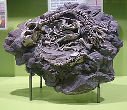
Picture of Dicynodontia
- Source
- Wikipedia/Commons
- Credit
- Nkansahrexford
- Licence
- CC BY 3.0
- Commercial use
- the licence allows it
Structured light scan
- Source
- MorphoSource
- Licence
- In Copyright
- Commercial use
- cannot be read from the licence given — check the record
- Specimen
- Dicynodontia indet. · NHMUK:PAL:PV R 12710
The description on this site
- Licence
- CC BY-SA 4.0
This is what the site found, which is not the same as what exists.
Keep going
What may have been alongside itAnomodontia through timeFormations of the PermianThe world it lived on
Occurrence data from the Paleobiology Database, CC BY 4.0. (Owen 1859)