Ammonitida
Ammonitida, or true ammonites, are an order of ammonoid cephalopods that lived from the Jurassic through Paleocene time periods, commonly with intricate ammonitic sutures.

Gunnar Ries · CC BY-SA 3.0 · via Wikipedia/Commons. May be a photograph of a specimen, or an artist’s reconstruction — an interpretation of a skeleton, since colour and soft tissue are almost never preserved.
On record
Recorded, not inferred- Also called
- ammonitePBDB
- Sits inside
- AmmonoideaPBDB
- Diet
- carnivorePBDB, for Ammonoidea
- Life habit
- nektonicPBDB, for Ammonoidea
- Motility
- fast-movingPBDB, for Ammonoidea
- Vision
- well-developedPBDB, for Cephalopoda
- Environment
- marinePBDB, for Cephalopoda
Time the record covers
At least 333 million years on record.
The record covers at least 399.5 Mya to 66 Mya. No occurrence read is dated outside 419.62 Mya to 61.66 Mya.
12,000+ occurrences of Ammonitida on record. The Paleobiology Database records this as a living group, and the chart stops with its fossils rather than at the present. Bar height is expected occurrences, not a count: each fossil is spread across the span it is dated to, so a tall narrow bar means tight dating and a low wide one means loose.
When
12,000 occurrences read- Devonian6%
- Late Triassicunder 1%
- Early Jurassic23%
- Middle Jurassic9%
- Late Jurassic13%
- Early Cretaceous30%
- Late Cretaceous18%
- Paleoceneunder 1%
These are dates about fossils, not the animal: the record can only begin after it arose and end before it died out, so either end may reach further. Shares are expected occurrences: a fossil dated to a span is counted partly in each period it straddles. The read hit its cap, so every figure above is a floor and the shares are of the occurrences read. More on what this infers.
Found in
at least 385 formations
- Grès verts helvétiques Formation630
- Jurensismergel Formation485
- Fannin Formation · Maude Group375
- Whiteaves Formation · Maude Group347
- Spatsizi Formation · Hazelton Group277
- Nishinakayama Formation · Toyora Group234
Loading coastlines…
The named rock units Ammonitida has been recovered from, largest first. Drawn where the rock is now, not where it formed. The read hit its cap, so each count is a floor. 361 further formations hold fewer occurrences each and are not listed. 4,056 occurrences have no formation on record, which is common for older literature.
Found in the same rock
679 taxa- Bryozoa55 sites
- Inoceramus38 sites
- Hoploscaphites35 sites
- Cataceramus subcompressus26 sites
- Deshayesites20 sites
- Baculites gregoryensis18 sites
- Baculites perplexus18 sites
- Nuculana18 sites
- Resatrix18 sites
- Cheloniceras17 sites
- Exogyra15 sites
- Tropaeum15 sites
- Baculites gilberti14 sites
- Douvilleiceras mammillatum14 sites
- Baculites13 sites
- Euspira13 sites
- Ostrea13 sites
- Thetironia minor13 sites
- Baculites eliasi12 sites
- Entolium orbiculare12 sites
- Eurotrigonia mantelli12 sites
- Hypacanthoplites12 sites
- Panopea12 sites
- Anchura11 sites
The Paleobiology Database records at least 477 sites for Ammonitida, and this reads 240 of them. The number is how many of those sites it was catalogued from too. The 24 sharing the most are listed.
This is not a list of everything alive at the time. It is only what has come out of the same ground as this animal and been written down.
Entered from
at least 339 references- Les grès verts helvétiques (Aptien moyen-Albien supérieur) de Haute-Savoie, Valais et Vaud (Alpes occidentales franco-suisses)845
- Toarcian (Early Jurassic) ammonoids from western North America671
- Lower Barremian ammonite biostratigraphy in the Subbetic Domain (Betic Cordillera, southern Spain)610
- The stratigraphical palaeontology of the Lower Greensand528
- Pliensbachian (Lower Jurassic) ammonites of the Queen Charlotte Islands, British Columbia497
- L'Oxfordien dans la moitié sud du Jura francais - etude stratigraphique407
- Early Jurassic Bivalvia of western Canada. Part I. Subclasses Palaeotaxodonta, Pteriomorpha, and Isofilibranchia310
- Die Ammonitenfauna und Stratigraphie der Tongrube Mistelgau bei Bayreuth (Oberfranken)283
- La succession des faunes dans le Callovien Francais, essais de corrélation à l'échelle de la zone272
- Untersuchungen zur Paläontologie der Cephalopoden des Unter-Tithon der Südlichen Frankenalb265
- Quantitative stratigraphy and taxonomy of late Emsian and Eifelian ammonoids of the eastern Anti-Atlas (Morocco)264
- Die Grenzziehung Unter-/Mitteljura (Toarcium/Aalenium) bei Wittnau und Fuentelsaz [Determinig the boundary between Toarcium/Aalenium near Wittnau and Fuentelsaz]256
Each of the 12,000 occurrences read was entered from one of these publications, ordered by how many each accounts for. This is not a search for papers mentioning the name. That read hit its cap, so each count is a floor. 327 further references are not listed. Entries link to doi.org where the Paleobiology Database holds an identifier, and to its own record where it does not. Relayed as the Paleobiology Database holds them, not checked against what they resolve to.
Media and terms
Media content2

Picture of Ammonitida
- Source
- Wikipedia/Commons
- Credit
- Gunnar Ries
- Licence
- CC BY-SA 3.0
- Commercial use
- the licence allows it
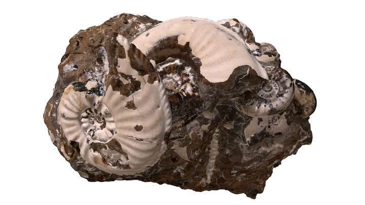
3D model
- Source
- Sketchfab
- Licence
- CC Attribution
- Commercial use
- cannot be read from the licence given — check the record
The description on this site
- Source
- Wikipedia, “Ammonitida”
- Licence
- CC BY-SA 4.0
This is what the site found, which is not the same as what exists.
Keep going
What may have been alongside itAmmonoidea through timeThe world it lived on
Occurrence data from the Paleobiology Database, CC BY 4.0. Haeckel 1866