Mulinia lateralis
Mulinia lateralis, the dwarf surf clam or coot clam, is a species of small saltwater clam, a bivalve mollusc in the family Mactridae. It occurs in the western Atlantic Ocean and the Caribbean Sea.

Eric A. Lazo-Wasem · CC0 · via Wikipedia/Commons. May be a photograph of a specimen, or an artist’s reconstruction — an interpretation of a skeleton, since colour and soft tissue are almost never preserved.
On record
Recorded, not inferred- Sits inside
- MuliniaPBDB
- Diet
- suspension feederPBDB, for Mulinia
- Life habit
- infaunalPBDB, for Mulinia
- Motility
- facultatively mobilePBDB, for Mulinia
- Vision
- blindPBDB, for Bivalvia
Time the record covers
At least 15 million years on record.
The record covers at least 15.98 Mya to 11.7 ka. No occurrence read is dated outside 23.04 Mya to 0 Mya.
126 occurrences of Mulinia lateralis on record, most of them in the Pleistocene. The Paleobiology Database records this as a living group. Bar height is expected occurrences, not a count: each fossil is spread across the span it is dated to, so a tall narrow bar means tight dating and a low wide one means loose.
When
126 occurrences- Miocene10%
- Pliocene6%
- Pleistocene77%
- Holocene8%
These are dates about fossils, not the animal: the record can only begin after it arose and end before it died out, so either end may reach further. Shares are expected occurrences: a fossil dated to a span is counted partly in each period it straddles. More on what this infers.
Found in
22 formations
- Pamlico Formation22
- Caloosahatchee Formation11
- Flanner Beach Formation7
- Acredale Formation6
- James City Formation6
- Gatun Formation5
Loading coastlines…
The named rock units Mulinia lateralis has been recovered from, largest first. Drawn where the rock is now, not where it formed. 20 occurrences have no formation on record, which is common for older literature.
Mulinia lateralis and its relatives
PleistoceneWhere Mulinia lateralis and its relatives were recorded in the Pleistocene.
Found in the same rock
1,294 taxa- Neverita duplicatus31 sites
- Anadara (Larkinia) transversa27 sites
- Abra aequalis26 sites
- Nucula (Nucula) proxima26 sites
- Crepidula fornicata25 sites
- Anomia simplex22 sites
- Nuculana acuta22 sites
- Crepidula plana21 sites
- Oliva (Ispidula) sayana21 sites
- Crassostrea virginica20 sites
- Mercenaria campechiensis20 sites
- Olivella mutica20 sites
- Parvilucina multistriata20 sites
- Acteocina canaliculata19 sites
- Crassinella lunulata19 sites
- Balanus17 sites
- Chione cancellata17 sites
- Rangia (Rangia) cuneata17 sites
- Conradostrea sculpturata16 sites
- Lunarca ovalis16 sites
- Nassarius vibex16 sites
- Neoterebra dislocata16 sites
- Angulus texanus15 sites
- Astyris lunata15 sites
The Paleobiology Database records 71 sites for Mulinia lateralis, and this reads all of them. The number is how many of those sites it was catalogued from too. The 24 sharing the most are listed.
This is not a list of everything alive at the time. It is only what has come out of the same ground as this animal and been written down.
Entered from
27 references- Studies on the marine Pleistocene: Part II. The marine Pleistocene mollusks of eastern North America30
- Unpublished census data from Atlantic coastal plain and circum-Caribbean Neogene assemblages and taxonomic opinions23
- The Flanner Beach Formation (Middle Pleistocene) in eastern North Carolina7
- Neogene Biostratigraphy of the Charlotte Harbor Area in Southwestern Florida7
- Geology and paleontology of canal zone and adjoing parts of Panama: Description of Tertiary mollusks (Pelecypods: Propeamussiidae to Cuspidariidae).5
- Neogene Stratigraphy of the lower Coast Plain of the Carolinas5
- Neogene and Quaternary geology of a stratigraphic test hole on Horn Island, Mississippi Sound4
- Checklist of megafossils from the James City Formation (Lower Pleistocene) at Johnson Point, Craven County, North Carolina4
- The fauna and paleoecology of the Late Pleistocene marine sediments of southeastern Virginia4
- Stratigraphy of newly exposed Quaternary sediments, eastern Orleans Parish, Louisiana4
- Stratigraphy of newly exposed Quaternary seduments, eastern Orleans Parish, Louisiana4
- Well-boring at Brandywine Lighthouse in Delaware Bay. Part I. - Geology and Macrofossils4
Each of the 126 occurrences read was entered from one of these publications, ordered by how many each accounts for. This is not a search for papers mentioning the name. 15 further references are not listed. Entries link to doi.org where the Paleobiology Database holds an identifier, and to its own record where it does not. Relayed as the Paleobiology Database holds them, not checked against what they resolve to.
Media and terms
Media content2
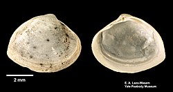
Picture of Mulinia lateralis
- Source
- Wikipedia/Commons
- Credit
- Eric A. Lazo-Wasem
- Licence
- CC0
- Commercial use
- the licence allows it
CT scan
- Source
- MorphoSource
- Licence
- not stated by the source
- Commercial use
- cannot be read from the licence given — check the record
- Specimen
- Mulinia lateralis · USNM:IZ:USNM 592295
Smithsonian Open Access was not reached for this taxon, so this list is what the others held rather than everything there is.
The description on this site
- Licence
- CC BY-SA 4.0
This is what the site found, which is not the same as what exists.
Keep going
What may have been alongside itMulinia through timeFormations of the PleistoceneThe world it lived on
Occurrence data from the Paleobiology Database, CC BY 4.0. (Say 1822)